
![]() f
there is a bright side to the persistent rains of the past 7 days or so, I suppose
it’s that many growers have been able to work on those rainy day jobs
they’ve been procrastinating on since the beginning of this planting season.
By now, though, there’s probably a lot of thumb twiddling going on as
storms continue to rumble through the state, further delaying the completion
of corn and soybean planting.
f
there is a bright side to the persistent rains of the past 7 days or so, I suppose
it’s that many growers have been able to work on those rainy day jobs
they’ve been procrastinating on since the beginning of this planting season.
By now, though, there’s probably a lot of thumb twiddling going on as
storms continue to rumble through the state, further delaying the completion
of corn and soybean planting.
Maybe you were fortunate enough to have received some GPS toys from Santa this past Christmas. Perhaps he left you a new pocket PC outfitted with a WAAS-enabled DGPS receiver and some nifty field mapping software? Maybe these new GPS toys helped you justify the purchase of that new ATV so that you could map a few field boundaries while you cruise around the farm?
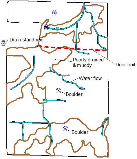
Now that you’ve mapped the boundaries of every field on your farm (and maybe your neighbor’s fields, too) with these toys and grid soil sampled down to the nearest half acre, what else is there to do with these high-priced high-tech gadgets? The current delay to the finish of corn and soybean planting offers an opportunity for georeferencing (mapping) potential yield limiting factors now while you’re waiting for the fields to dry out.
Once you've mapped these yield limiting factors, don't stop for the season. Put these GPS-enabled mapping and scouting devices to work throughout the year as other yield limiting factors develop.
Successful yield map interpretation depends on more than just soil maps and intensive soil nutrient sampling. There are a gozillion factors that influence the yield of corn and soybean, the combinations and spatial locations of which change every year. Successful site-specific crop management depends on site-specific identification of as many of these yield-limiting factors as is humanly possible.
IIf Santa did not bring you any handheld GPS toys, the following Web sites may help you choose some for yourself.
© 2006 , Purdue University, an equal access, equal opportunity university. This material may be available in alternative formats. If you have trouble accessing this page because of a disability, please contact RLNielsen at rnielsen@purdue.edu.